After the CZU fires, the Santa Cruz Mountains Stewardship Network jumped into action.
The collaboration between 24 organizations includes land trusts, public agencies like Cal Fire, universities like Stanford and UCSC, the Amah Mutsun Tribal Band, the Girl Scouts and logging companies like Big Creek Lumber.
“There’s all these different organizations that do really different things in the region, and the purpose of the network was for them to all collaborate, especially on issues that cross boundaries like fire, climate change and invasive species,” says the Network’s manager Dylan Skybrook.
Their largest effort is a vegetation mapping project made up of LiDAR data collected from planes. This remote sensing method uses lasers to measure distance—similar to echolocation or sonar, but with light instead of sound.
The resulting information is paired with high-resolution imagery and ground-based vegetation classification to provide a detailed map of the forests.
The project spans all of Santa Cruz and Santa Clara Counties and expands work already completed in Sonoma, Napa, Marin and San Mateo.
The network is using the data to create a wildfire risk map for Cal Fire
“This will show generally where the priorities should be for fuel-reduction projects,” says Skybrook. “It’s literally going to save homes and lives.”
The project had collected LiDAR before the CZU fires. In the immediate aftermath of the fire, Cal Fire used the original LiDAR for hazard assessments and Santa Cruz County geologists used it to predict potential debris flows.
“But once the fire came, that really changed the landscape,” says Skybrook. “So we went back and raised more money, and we have now collected LiDAR post-fire in the burn area, which will give an incredible amount of information for people who are working in this area to understand what the changes were.”
Fungi to the Rescue
While far smaller than the vegetation mapping project, one of the most innovative efforts comes from CoRenewal, a nonprofit working in post-fire ecological regeneration. The organization studies the potential for fungi and microbial communities to break down toxic material and stabilize soil after fires.
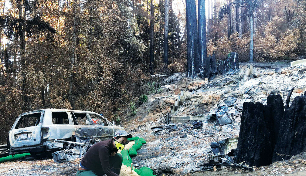
In 2020, CoRenewal set up five study sites in burn scars across the Central Coast, including the CZU. They inoculated wattles—erosion control materials—with a subspecies of oyster mushroom to break down burnt materials.
“The idea is to bring in fungi that have been known to be able to break down a number of different petroleum-based toxins. They can decompose them and make them less toxic,” says CoRenewal executive director Maya Elson.
“The other thing that we’re trying to do is to sequester the heavy metals. Heavy metals can’t be broken down, but we were hoping to stop them from moving into the waterways below and concentrate them to bring them to a hazardous waste facility and get them out of the environment.”
While researchers know certain mushrooms have the ability to break down plastics and sequester heavy metals, this is the first large-scale study of its kind.
The organization is also trying to increase soil health using local microbial communities and mycorrhizal fungi, which bind soil together and reduce erosion risk.
Elson calls it a “probiotic for the soil.”
“If we can just bring the different pieces of the puzzle, nature can take care of itself,” she says.
“It’s really not about playing god and deciding, ‘I know what’s best for this ecosystem all the time.’ It’s a process of deeply listening to the land and observing before taking action.”
But they only had so much time to listen before winter storms further threatened the land.
“Often you’re in this incredible rush between when the fire happens and when the rains are predicted to come, so it’s a tricky thing to balance,” says Elson.
The three-year study, led by UC Riverside postdoctoral scholar Mia Maltz, will transition into a new phase soon.
“There’s a lot of ways for people to get involved if they live locally,” says Elson. “We have a work party coming up August 26 and 27 and a workshop on August 28.
Forest Reset
Land stewardship in the Santa Cruz Mountains is made particularly complex by how many people live and work there.
“We have a very unique county in the sense that we have a really high population that lives in our forest. It’s called the ‘wildland-urban interface,’ and about 60% of the population lives in that area,” says Matt Abernathy, the forest health program specialist for the Resource Conservation District of Santa Cruz County.
The RCD is a state-mandated special district focused on stewardship.
“Our specific mission is to help people help the land,” says Abernathy. The district plans educational events, technical assistance and manages large projects.
After the CZU fires, the RCD offered information, hosted a webinar series about recovery with local experts and offered individual site assessments.
“We had over 400 requests, some of those for individual homes, some of them for communities,” says Abernathy.
Now, the RCD focuses on long-term recovery efforts and making a more resilient landscape.
At one project site along Last Chance Road, the RCD is helping landowners encourage the regrowth of Monterey pines.
“Historically, in California, we have three areas that naturally will grow Monterey pine,” says Abernathy. Año Nuevo has the northernmost stand, and it used to extend south through Big Basin along the coast.
“Slowly over time, other species like Douglas fir and some hardwoods like our Coast Live Oak have grown over the Monterey pine. They’ve out-shaded it and taken over that space.”
The fire, devastating as it was, provided a chance to start over.
“The first thing that came back were all these little Monterey pine seedlings,” says Abernathy. “The seeds were just waiting for an opportunity to come back and to reoccupy this area. So it’s a cool chance to see how nature is super dynamic.”
See for Yourself
For those interested in watching forest recovery in action, Big Basin State Park recently reopened sections of the park and offers 84 day-use parking spaces and four ADA spaces each day. Visitors must reserve a space through thatsmypark.org/bigbasin.
The old growth loop and about 18 miles of backcountry fire roads are currently open.
“Our next push will be along the Skyline to Sea trail as it parallels North Escape Road. And we’ll just keep pushing out further into the backcountry to open more trails,” says California State Parks-Santa Cruz District Superintendent Chris Spohrer.
Park staff are trying to make the area safe and accessible quickly, which includes inspecting and removing hazard trees within more than 18,000 acres. But they don’t want to bulldoze blindly toward the single goal of reopening.
“We want to be very thoughtful and try to be inclusive in our planning process,” says Spohrer. “So, we’ve started that reimagining process with the public as quickly as we could.”
The recovery efforts have helped more than just the forests.
“A lot of our staff lost houses and lost all their possessions and lost their place to work along with many of our neighbors and community members,” says Spohrer. “Seeing them rally around the idea of being able to recover the park and work with the public on being productive—that’s been a great thing to watch.”
Full recovery will take years, but senior environmental scientist Joanne Kerbavaz says things are progressing as expected. Even with the added challenges of drought and higher temperatures, the redwoods are resprouting, chaparral areas are filling back in, and fire-followers like bush poppy and California lilac add pops of color to the understory.
“In some cases, the length of time to return to what things looked like before the fire will probably be very long,” says Kerbavaz. “But even in the harshest, most difficult places, I’ve yet to see areas that aren’t regenerating.”
The Santa Cruz Mountains Stewardship Network’s vegetation-mapping data is publicly available at pacificvegmap.org.


